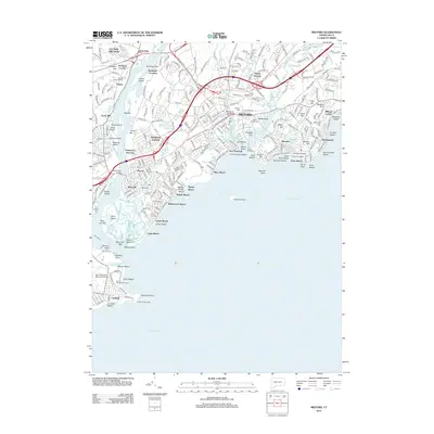
2012 Map of Milford
USGS Topo · Published 2012About this map
The Housatonic River meets Long Island Sound in this detailed 2012 study of the Connecticut shoreline, highlighting the complex relationship between the estuary and the urban development of Milford. The landscape is defined by its coastal geography, from the protective sandbars of Charles Island and Milford Point to the heavily developed reaches of Devon and Lordship. The map records a modern transportation network where the Metro-North Railroad and major spans like the Washington Bridge cross the water, alongside specialized facilities such as the Igor I Sikorsky Memorial Airport. Interior features reveal the civic history of the region, including the Milford Cem and the former grounds of Arnold College. Small ponds and marshlands, including Gulf Pond and Beaver Brook Ponds, remain interspersed among the residential neighborhoods of Morningside and Wildermere Beach, illustrating the persistent coastal hydrology of the South Central Connecticut Planning Region.
Find a feature on this map
96 named features on this map. Tap any name to fly to it.
Don’t see what you’re looking for? This feature index may not catch every label — zoom into the map to look around manually.
Map Details
Editions of this 2012 Milford Map
This is the sole edition of this map. No revisions or reprints were ever made.
Other maps of this area

1889 · Derby
USGS Topo · 1:62,500

1891 · Bridgeport
USGS Topo · 1:62,500

1891 · Derby
USGS Topo · 1:62,500

1892 · New Haven
USGS Topo · 1:62,500

1893 · Bridgeport
USGS Topo · 1:62,500

1893 · Derby
USGS Topo · 1:62,500

1920 · Bridgeport
USGS Topo · 1:62,500

1921 · New Haven
USGS Topo · 1:62,500

1943 · New Haven
USGS Topo · 1:31,680
1947 · Long Hill
USGS Topo · 1:31,680