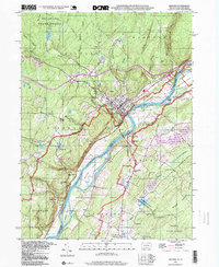
1995 Map of Milford
USGS Topo · Published 1999About this map
Milford serves as a focal point along the Delaware River, where the borough's grid is defined by the steep descent of Sawkill Creek and the proximity of The Knob. This late-twentieth-century landscape reflects a region deeply shaped by public conservation, with the Delaware Water Gap National Recreational Area encompassing the river's path and its significant islands like Minisink Island and Namanock Island. Across the water in New Jersey, smaller settlements such as Montague, Shaytown, and Hainesville are connected by rural routes past the Township Sch and Minisink Ch. The map details a transition from the structured streets of the county seat to the wilder reaches of the Delaware State Forest, where features like Raymondskill Falls and Indian Point mark the dramatic geology of the river valley. Local history is preserved in sites like Milford Cem and the Hainesville Cem.
Find a feature on this map
57 named features on this map. Tap any name to fly to it.
Don’t see what you’re looking for? This feature index may not catch every label — zoom into the map to look around manually.
Map Details
Editions of this 1995 Milford Map
This is the sole edition of this map. No revisions or reprints were ever made.
Other maps of this area

1888 · Franklin
USGS Topo · 1:62,500

1891 · Wallpack
USGS Topo · 1:62,500

1893 · Wallpack
USGS Topo · 1:62,500

1894 · Franklin
USGS Topo · 1:62,500

1897 · Franklin
USGS Topo · 1:62,500

1903 · Franklin Furnace
USGS Topo · 1:62,500

1906 · Port Jervis
USGS Topo · 1:62,500

1908 · Port Jervis
USGS Topo · 1:62,500

1913 · Milford
USGS Topo · 1:62,500

1915 · Milford
USGS Topo · 1:62,500
Featured Places
- Montague Township, NJ
- Sandyston Township, NJ
- Abertown, Sandyston Township
- Shaytown, Sandyston Township
- Quinns Corner, Dingman Township