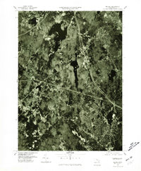
1977 Map of Milford
USGS Topo · Published 1980About this map
The town of Milford and its surrounding suburban landscape are captured here in the late 1970s, showcasing a period of significant development in the Blackstone Valley region. This orthophotograph, produced by the Geological Survey and the Massachusetts Department of Public Works, reveals the dense residential patterns forming around the historical centers of Hopedale and Hopkinton. The aerial perspective provides a clear view of the industrial and residential corridors that define the area, contrasting the built environment with natural water features like North Pond and the headwaters of the Charles River. To the northwest, the smaller settlement of Woodville sits near the edge of the quadrangle, while Upton marks the western boundary. This survey offers a precise record of the regional infrastructure and land-use shifts occurring during the decade.
Find a feature on this map
7 named features on this map. Tap any name to fly to it.
Don’t see what you’re looking for? This feature index may not catch every label — zoom into the map to look around manually.
Map Details
Editions of this 1977 Milford Map
This is the sole edition of this map. No revisions or reprints were ever made.
Other maps of this area

1886 · Blackstone
USGS Topo · 1:62,500

1886 · Framingham
USGS Topo · 1:62,500

1887 · Franklin
USGS Topo · 1:62,500

1887 · Marlboro
USGS Topo · 1:62,500

1889 · Marlboro
USGS Topo · 1:62,500

1889 · Blackstone
USGS Topo · 1:62,500

1889 · Franklin
USGS Topo · 1:62,500

1889 · Framingham
USGS Topo · 1:62,500

1893 · Franklin
USGS Topo · 1:62,500

1893 · Blackstone
USGS Topo · 1:62,500