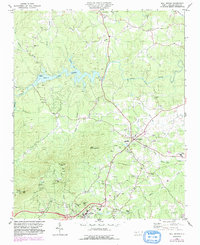
1982 Map of Mill Spring
USGS Topo · Published 1990About this map
Lake Adger dominates the northern landscape of this Polk County region, where the Green River flows toward the foothills. The map documents the infrastructure of the early 1980s, including a powerplant and substation situated along the river's edge, reflecting the utility development of the era. Settlement patterns are concentrated around Mill Spring and the county seat of Columbus at the southern edge, connected by a network of rural roads and several routes marked as under construction.
Find a feature on this map
45 named features on this map. Tap any name to fly to it.
Don’t see what you’re looking for? This feature index may not catch every label — zoom into the map to look around manually.
Map Details
Editions of this 1982 Mill Spring Map
2 editions found
Other maps of this area

1907 · Saluda
USGS Topo · 1:125,000

1935 · Batcave
USGS Topo · 1:24,000

1935 · Fishtop
USGS Topo · 1:24,000

1946 · Bat Cave
USGS Topo · 1:24,000

1946 · Cliffield Mtn
USGS Topo · 1:24,000
1947 · Bat Cave
USGS Topo · 1:24,000

1947 · Cliffield Mtn.
USGS Topo · 1:24,000

1955 · Knoxville
USGS Topo · 1:250,000

1957 · Knoxville
USGS Topo · 1:250,000

1959 · Lake Lure
USGS Topo · 1:62,500