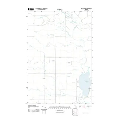
2011 Map of Millecoquins
USGS Topo · Published 2011About this map
Millecoquins Lake and its intricate river systems define this Upper Peninsula landscape in Mackinac County. The Upper Millecoquins River feeds into the lake from the northeast, while the Lower Millecoquins River drains it to the south, creating a complex wetland and woodland environment. To the east of the small settlement at Millecoquins, the land is marked by numerous seasonal creeks and ponds, including Millecoquins Pond and McAlpine Pond. Local history and genealogy interest is anchored by the Bethlehem Lutheran Cemetery located centrally along Wentland Rd. The terrain transition from the lake shore at Chases Point to the interior is mapped through a network of local forest trails and county roads like Indian Trl and Krause Rd, providing a clear record of land use and navigation in this timber and water-rich region.
Find a feature on this map
39 named features on this map. Tap any name to fly to it.
Don’t see what you’re looking for? This feature index may not catch every label — zoom into the map to look around manually.
Map Details
Editions of this 2011 Millecoquins Map
This is the sole edition of this map. No revisions or reprints were ever made.
Other maps of this area

1931 · Gould City NE
USGS Topo · 1:31,680

1931 · Gould City NW
USGS Topo · 1:31,680

1931 · Gould City SE
USGS Topo · 1:31,680

1931 · Gilchrist NW
USGS Topo · 1:31,680

1954 · Sault Sainte Marie
USGS Topo · 1:250,000

1956 · Sault Sainte Marie
USGS Topo · 1:250,000

1957 · Sault Sainte Marie
USGS Topo · 1:250,000

1958 · Sault Sainte Marie
USGS Topo · 1:250,000
1973 · Curtis East
USGS Topo · 1:24,000
1973 · McMillan
USGS Topo · 1:24,000