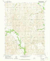
1962 Map of Miller NE
USGS Topo · Published 1964About this map
The South Loup River and Wood River define the hydraulic character of this Buffalo County landscape, where the flat valley floors of Cherry Valley contrast with the dissected uplands. This 1960s era survey captures a rural environment organized by section lines and small community centers. The Union Pacific railroad cuts a diagonal path through the Armada and Scott townships, serving as a primary transportation corridor alongside Route 40. Local social life is anchored by landmarks such as Immanuel Lutheran Ch and Grandview Ch. The presence of Watertown Sch and Maple Grove Sch reflects a period of localized rural education before further consolidation. From the northern flow of Death Creek to the southern reaches of the Wood River, the map provides a detailed view of the infrastructure and land use in these Nebraska townships.
Find a feature on this map
16 named features on this map. Tap any name to fly to it.
Don’t see what you’re looking for? This feature index may not catch every label — zoom into the map to look around manually.
Map Details
Editions of this 1962 Miller NE Map
This is the sole edition of this map. No revisions or reprints were ever made.
Other maps of this area

1896 · Kearney
USGS Topo · 1:125,000

1951 · Litchfield SW
USGS Topo · 1:24,000

1951 · Mason City SW
USGS Topo · 1:24,000

1951 · Mason City SE
USGS Topo · 1:24,000

1955 · Broken Bow
USGS Topo · 1:250,000

1955 · Grand Island
USGS Topo · 1:250,000

1956 · Broken Bow
USGS Topo · 1:250,000

1957 · Grand Island
USGS Topo · 1:250,000

1958 · Grand Island
USGS Topo · 1:250,000

1961 · Amherst
USGS Topo · 1:24,000