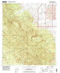
1996 Map of Miller Peak
USGS Topo · Published 2002About this map
The Fort Huachuca Military Reservation dominates the northern reaches of this high-altitude landscape, where the Huachuca Mountains rise toward the Huachuca Peak quadrangle boundary. This 1996 survey illustrates a landscape defined by its extractive history and military presence, featuring a high density of mining sites such as the Hamburg Mine, Pomona Mine, and the Reef Mine in the southern reaches of the Coronado National Forest.
Find a feature on this map
67 named features on this map. Tap any name to fly to it.
Don’t see what you’re looking for? This feature index may not catch every label — zoom into the map to look around manually.
Map Details
Editions of this 1996 Miller Peak Map
This is the sole edition of this map. No revisions or reprints were ever made.
Other maps of this area

1914 · Hereford
USGS Topo · 1:125,000

1915 · Benson
USGS Topo · 1:125,000

1922 · Sunnyside
USGS Topo · 1:62,500

1932 · Stark
USGS Topo · 1:62,500

1932 · Fairbank
USGS Topo · 1:62,500

1938 · Huachuca
USGS Topo · 1:62,500

1938 · Sunnyside
USGS Topo · 1:62,500

1943 · Benson
USGS Topo · 1:125,000

1948 · Huachuca Peak
USGS Topo · 1:24,000

1948 · Miller Peak
USGS Topo · 1:24,000
Featured Places
- Sierra Vista, AZ
- Bledsoe, Sierra Vista
- Ramsey, Sierra Vista
- Sierra Vista Estates, Sierra Vista
- Cochise County, AZ