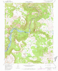
1965 Map of Millerton Lake East
USGS Topo · Published 1981About this map
San Joaquin River canyon walls and the rising waters of Millerton Lake define this mid-1960s landscape on the Fresno and Madera County line. The terrain transitions from the volcanic cap of Kennedy Table and Table Mountain down to the alluvial floor of Auberry Valley. The map documents a diverse infrastructure of mid-century utility and recreation, including the Kerckhoff Powerhouse and a Gaging Station on the river, alongside the Millerton Lake State Recreation Area. To the east, the settlement of Prather sits near the Auberry School and Auberry Cemetery, serving as a local hub for the surrounding ranching and mining country. Small-scale resource extraction is evident at the Sullivan Mine and various prospects scattered across the slopes leading into the Sierra National Forest.
Find a feature on this map
39 named features on this map. Tap any name to fly to it.
Don’t see what you’re looking for? This feature index may not catch every label — zoom into the map to look around manually.
Map Details
Editions of this 1965 Millerton Lake East Map
4 editions found
Other maps of this area

1904 · Kaiser
USGS Topo · 1:125,000

1912 · Mariposa
USGS Topo · 1:125,000

1916 · Sulphur Springs
USGS Topo · 1:24,000

1919 · Sulphur Springs
USGS Topo · 1:31,680

1922 · Trimmer
USGS Topo · 1:96,000

1922 · Friant
USGS Topo · 1:31,680

1923 · Academy
USGS Topo · 1:31,680

1924 · Dinuba
USGS Topo · 1:125,000

1942 · Watts Valley
USGS Topo · 1:62,500

1942 · Millerton Lake
USGS Topo · 1:62,500