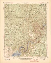
1945 Map of Millerton Lake
USGS Topo · Published 1945About this map
Millerton Lake and the winding San Joaquin River dominate the southern portion of this landscape, marking the rugged boundary between Madera and Fresno counties in the mid-1940s. The region is defined by a series of high tablelands and prominent peaks such as Pincushion Mtn, Smiley Mtn, and Hildreth Mtn. Settlement is largely characterized by scattered ranching operations, including the Vester Ranch, Hadley Ranch, and the 101 Ranch, interspersed with isolated mining efforts like the Fresno Banner Mine and Carnation Mine.
Find a feature on this map
66 named features on this map. Tap any name to fly to it.
Don’t see what you’re looking for? This feature index may not catch every label — zoom into the map to look around manually.
Map Details
Editions of this 1945 Millerton Lake Map
2 editions found

Other maps of this area

1904 · Kaiser
USGS Topo · 1:125,000

1912 · Mariposa
USGS Topo · 1:125,000

1916 · Sulphur Springs
USGS Topo · 1:24,000

1919 · Sulphur Springs
USGS Topo · 1:31,680

1919 · Little Table Mountain
USGS Topo · 1:31,680

1922 · Trimmer
USGS Topo · 1:96,000

1922 · Lanes Bridge
USGS Topo · 1:31,680

1922 · Friant
USGS Topo · 1:31,680

1923 · Academy
USGS Topo · 1:31,680

1924 · Dinuba
USGS Topo · 1:125,000