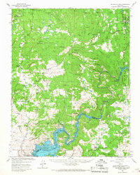
1965 Map of Millerton Lake
USGS Topo · Published 1967About this map
The San Joaquin River corridor and its surrounding cattle country are depicted here in the mid-1960s, a landscape defined by the massive impoundment of Millerton Lake behind Friant Dam. This area represents a crossroads of ranching heritage and modern water management, where old family holdings like Veater Ranch, Housel Ranch, and Lewis Ranch sit adjacent to the expanding Millerton Lake State Recreation Area. In the north, the foothills are dotted with evidence of earlier industry and community, including the Quartz Mine near Quartz Mtn and quiet local landmarks like Picayune Cem. The presence of Spring Valley Sch and the community of O'Neals highlights the enduring rural infrastructure of Madera County during this period of transition from traditional mining and grazing toward a recreational and hydroelectric economy, as seen at Kerckhoff Lake.
Find a feature on this map
76 named features on this map. Tap any name to fly to it.
Don’t see what you’re looking for? This feature index may not catch every label — zoom into the map to look around manually.
Map Details
Editions of this 1965 Millerton Lake Map
2 editions found
Other maps of this area

1904 · Kaiser
USGS Topo · 1:125,000

1912 · Mariposa
USGS Topo · 1:125,000

1916 · Sulphur Springs
USGS Topo · 1:24,000

1919 · Sulphur Springs
USGS Topo · 1:31,680

1919 · Little Table Mountain
USGS Topo · 1:31,680

1922 · Trimmer
USGS Topo · 1:96,000

1922 · Lanes Bridge
USGS Topo · 1:31,680

1922 · Friant
USGS Topo · 1:31,680

1923 · Academy
USGS Topo · 1:31,680

1924 · Dinuba
USGS Topo · 1:125,000