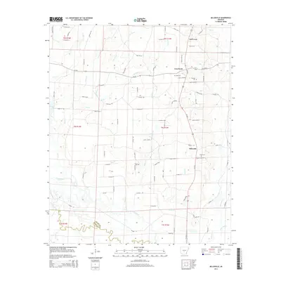
2014 Map of Millerville
USGS Topo · Published 2014About this map
The Saline River and its meandering tributaries define the geography of this rural corner of South Arkansas. In the mid-2010s, this landscape in Grant County remained characterized by small settlements like Millerville, Cross Roads, and Deer Creek. The area is bisected by Us-167 S and Ar-190, which connect these communities and provide access to the dense network of county roads. Local history is anchored by several rural landmarks, including Bethel Ch and a collection of family and community burial grounds such as Rhodes Cem and Shiloh Cem. The terrain is woven with minor waterways like Gamble Cr and W Br Flat Cr, illustrating the low-lying drainage patterns that flow toward the river. This survey provides a clear view of the modern rural infrastructure, from the timber-rich lands near Hurricane Cr to the path of the Jones Hill TRL.
Find a feature on this map
91 named features on this map. Tap any name to fly to it.
Don’t see what you’re looking for? This feature index may not catch every label — zoom into the map to look around manually.
Map Details
Editions of this 2014 Millerville Map
This is the sole edition of this map. No revisions or reprints were ever made.
Other maps of this area

1955 · Little Rock
USGS Topo · 1:250,000

1956 · Little Rock
USGS Topo · 1:250,000

1960 · Little Rock
USGS Topo · 1:250,000

1963 · Prattsville
USGS Topo · 1:24,000

1964 · Little Rock
USGS Topo · 1:250,000

1964 · Staves
USGS Topo · 1:24,000

1964 · Sheridan
USGS Topo · 1:24,000

1964 · Bunn
USGS Topo · 1:24,000
1964 · Millerville
USGS Topo · 1:24,000
1964 · Prague
USGS Topo · 1:24,000