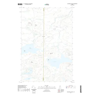
2021 Map of Millinocket Lake East
USGS Topo · Published 2021About this map
Millinocket Lake and Millimagassett Lake dominate this Northern Maine wilderness area, where the border between Piscataquis and Penobscot counties cuts through a landscape defined by complex waterways and timber ridges. The topography is shaped by the Aroostook River and the Seboeis River, with significant landmarks like Old Baldface and Libby Pinnacle rising above the marshy lowlands. The drainage network is particularly intricate here, featuring smaller bodies of water such as Big Marsh Pond, Tilly Pond, and Soule Pond. Human presence is marked by a series of primitive transport routes including Oxbow Rd and Seboeis Rd, while Millinocket Falls indicates a natural break in the river system. This area remains a crucial intersection of water routes and ridges, providing a clear view of the north woods hydrology before reaching more developed regions downstream.
Find a feature on this map
37 named features on this map. Tap any name to fly to it.
Don’t see what you’re looking for? This feature index may not catch every label — zoom into the map to look around manually.
Map Details
Editions of this 2021 Millinocket Lake East Map
This is the sole edition of this map. No revisions or reprints were ever made.
Other maps of this area

1954 · Shin Pond
USGS Topo · 1:62,500

1954 · Millinocket Lake
USGS Topo · 1:62,500

1954 · Grand Lake Seboeis
USGS Topo · 1:62,500

1954 · Presque Isle
USGS Topo · 1:250,000

1955 · Traveler Mountain
USGS Topo · 1:62,500

1958 · Presque Isle
USGS Topo · 1:250,000

1960 · Presque Isle
USGS Topo · 1:250,000
1975 · Shin Pond NW
USGS Topo · 1:24,000
1975 · Grand Lake Seboeis NW
USGS Topo · 1:24,000
1975 · Grand Lake Seboeis SW
USGS Topo · 1:24,000