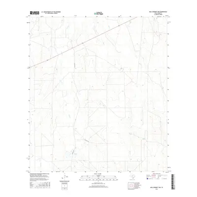
2016 Map of Mills Bennett NW
USGS Topo · Published 2016About this map
Torres Cr and Black Cr dominate the drainage patterns of this South Texas brush country, moving water through a landscape defined by ranching infrastructure. This 2016 survey captures a network of livestock tanks and water catchments essential for semi-arid land management, including Burro Tank, Willow Tank, and De Spain Tank. These features, often associated with specific landholding families, serve as critical landmarks in a region with few established settlements. Transportation is limited to a handful of thoroughfares, most notably the path of Highway 59 crossing the northern portion of the quadrangle and secondary routes like Welhousen Rd. The presence of Gates Lake near the northern boundary provides a distinct hydrological point of interest in an area otherwise characterized by ephemeral creeks such as Caliche Cr.
Find a feature on this map
10 named features on this map. Tap any name to fly to it.
Don’t see what you’re looking for? This feature index may not catch every label — zoom into the map to look around manually.
Map Details
Editions of this 2016 Mills Bennett NW Map
This is the sole edition of this map. No revisions or reprints were ever made.
Other maps of this area

1937 · Aguilete Creek
USGS Topo · 1:62,500

1956 · Becerra
USGS Topo · 1:62,500

1956 · Las Mujeres
USGS Topo · 1:62,500

1956 · Laredo
USGS Topo · 1:250,000
1968 · Mills Bennett SW
USGS Topo · 1:24,000

1968 · Mills Bennett
USGS Topo · 1:24,000

1968 · Mills Bennett NW
USGS Topo · 1:24,000

1968 · San Pablo
USGS Topo · 1:24,000
1974 · Biel Lake SE
USGS Topo · 1:24,000
1974 · Biel Lake South
USGS Topo · 1:24,000