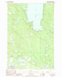
1988 Map of Milo North
USGS Topo · Published 1988About this map
Schoodic Lake dominates the northern landscape of this Maine survey, where the small settlement of Lake View rests along the shoreline. The geography is defined by a dense network of moving water, including the southern confluence where the Pleasant River and Sebec River join the larger Piscataquis River near the town of Milo. This area reveals a transition from the wooded uplands around Stickney Hill and Searles Hill to the fertile river valleys and meadows such as Hawthorne Meadow. Industrial and community life are grounded in several Gravel Pits and a Golf Course, while local genealogy is represented by a central Cem. The map also captures the distinct boundaries between Brownville, Lake View Plt, and Medford, showing how topography influenced the early division of these townships.
Find a feature on this map
34 named features on this map. Tap any name to fly to it.
Don’t see what you’re looking for? This feature index may not catch every label — zoom into the map to look around manually.
Map Details
Editions of this 1988 Milo North Map
This is the sole edition of this map. No revisions or reprints were ever made.
Other maps of this area

1932 · Dover-Foxcroft
USGS Topo · 1:48,000

1933 · Boyd Lake
USGS Topo · 1:62,500

1935 · Dover-Foxcroft
USGS Topo · 1:62,500

1940 · Sebec
USGS Topo · 1:48,000

1943 · Sebec
USGS Topo · 1:62,500

1947 · Schoodic
USGS Topo · 1:62,500

1949 · Schoodic
USGS Topo · 1:62,500

1951 · Boyd Lake
USGS Topo · 1:50,000

1954 · Millinocket
USGS Topo · 1:250,000

1955 · Boyd Lake
USGS Topo · 1:62,500