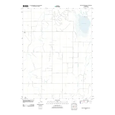
2010 Map of Milton Reservoir
USGS Topo · Published 2010About this map
Milton Reservoir dominates the northeastern corner of this Weld County landscape, where irrigation and aviation define the modern rural character. The map documents an intricate network of waterways essential for local agriculture, including the East Speer Canal, Speer Canal, and Beebe Seep Canal, which weave between a strict grid of county roads. The containment of the reservoir is marked at the Milton Lake Dam, near where the Gilmore Ditch departs. To the west, the Kugel-Strong Airport serves as a notable landmark alongside the gentle elevation of Riley Mound. This survey captures the transition of the high plains into a managed agricultural corridor, reflected in newer road names like Beebe Draw Farms Pkwy that suggest residential development encroaching on traditional farmland.
Find a feature on this map
28 named features on this map. Tap any name to fly to it.
Don’t see what you’re looking for? This feature index may not catch every label — zoom into the map to look around manually.
Map Details
Editions of this 2010 Milton Reservoir Map
This is the sole edition of this map. No revisions or reprints were ever made.
Other maps of this area

1902 · Greeley
USGS Topo · 1:125,000

1949 · Fort Lupton
USGS Topo · 1:24,000

1949 · Platteville
USGS Topo · 1:24,000

1949 · Hudson
USGS Topo · 1:24,000

1950 · Platteville
USGS Topo · 1:24,000
1950 · Fort Lupton
USGS Topo · 1:24,000

1950 · Keenesburg
USGS Topo · 1:24,000

1950 · Milliken
USGS Topo · 1:24,000

1950 · Klug Ranch
USGS Topo · 1:24,000

1950 · Valley View School
USGS Topo · 1:24,000