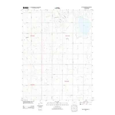
2013 Map of Milton Reservoir
USGS Topo · Published 2013About this map
Milton Reservoir dominates the northeastern corner of this landscape in Weld County, serving as the primary anchor for an extensive network of managed waterways. The terrain is defined by the Beebe Draw, a low-lying feature that organizes the local drainage and irrigation patterns. A complex system of canals and ditches, including the Beebe Seep Canal, E Speer Canal, and Neres Canal, crisscrosses the township lines of T003N and T002N. This infrastructure underscores the area's heavy reliance on water management for its development. To the west, the Kugel-Strong Airport represents a small pocket of specialized transportation amid a grid of county roads. The map reveals a transition toward modern residential development near the northern margin, evidenced by curvilinear streets like Beebe Draw Farms Pkwy and Stoneleigh Rd S, which contrast with the traditional rectilinear road grid found throughout the rest of the quadrangle.
Find a feature on this map
33 named features on this map. Tap any name to fly to it.
Don’t see what you’re looking for? This feature index may not catch every label — zoom into the map to look around manually.
Map Details
Editions of this 2013 Milton Reservoir Map
This is the sole edition of this map. No revisions or reprints were ever made.
Other maps of this area

1902 · Greeley
USGS Topo · 1:125,000

1949 · Fort Lupton
USGS Topo · 1:24,000

1949 · Platteville
USGS Topo · 1:24,000

1949 · Hudson
USGS Topo · 1:24,000

1950 · Platteville
USGS Topo · 1:24,000
1950 · Fort Lupton
USGS Topo · 1:24,000

1950 · Keenesburg
USGS Topo · 1:24,000

1950 · Milliken
USGS Topo · 1:24,000

1950 · Klug Ranch
USGS Topo · 1:24,000

1950 · Valley View School
USGS Topo · 1:24,000