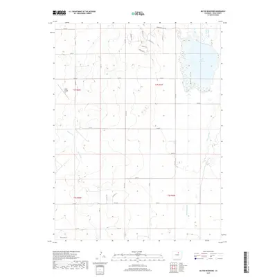
2019 Map of Milton Reservoir
USGS Topo · Published 2019About this map
Milton Reservoir dominates the northeastern landscape of this Weld County region, serving as the central hub for an intricate network of irrigation infrastructure including the Gilmore Ditch and Beebe Draw. The terrain is defined by the high plains of the Front Range, where agricultural water management is paramount, as evidenced by the numerous waterways like Speer Canal and Beebe Seep Canal that crisscross the sections. The 2019 survey shows a modern mix of traditional land use and infrastructure, featuring the private Kugel-Strong Airport and named agricultural sites like Klug Ranch. Local landmarks such as Riley Mound punctuate the topography, while the residential development of Beebe Draw Farms Pkwy signals changing land-use patterns in this rural Colorado corridor.
Find a feature on this map
38 named features on this map. Tap any name to fly to it.
Don’t see what you’re looking for? This feature index may not catch every label — zoom into the map to look around manually.
Map Details
Editions of this 2019 Milton Reservoir Map
This is the sole edition of this map. No revisions or reprints were ever made.
Other maps of this area

1902 · Greeley
USGS Topo · 1:125,000

1949 · Fort Lupton
USGS Topo · 1:24,000

1949 · Platteville
USGS Topo · 1:24,000

1949 · Hudson
USGS Topo · 1:24,000

1950 · Platteville
USGS Topo · 1:24,000
1950 · Fort Lupton
USGS Topo · 1:24,000

1950 · Keenesburg
USGS Topo · 1:24,000

1950 · Milliken
USGS Topo · 1:24,000

1950 · Klug Ranch
USGS Topo · 1:24,000

1950 · Valley View School
USGS Topo · 1:24,000