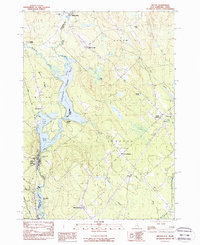
1983 Map of Milton
USGS Topo · Published 1984About this map
The Salmon Falls River serves as a natural and political boundary between New Hampshire and Maine, carving a chain of significant water bodies including Northeast Pond, Town House Pond, and Milton Pond. This river-centric geography dictates the local settlement pattern, with the village of Milton and the Boston and Maine railroad line following the western bank in Strafford County. The industrial and community legacy of the region is evident in the cluster of landmarks near the river, such as the Nute High Sch and the Town House.
Find a feature on this map
38 named features on this map. Tap any name to fly to it.
Don’t see what you’re looking for? This feature index may not catch every label — zoom into the map to look around manually.
Map Details
Editions of this 1983 Milton Map
2 editions found
Other maps of this area

1891 · Berwick
USGS Topo · 1:62,500

1891 · Newfield
USGS Topo · 1:62,500

1893 · Berwick
USGS Topo · 1:62,500

1893 · Newfield
USGS Topo · 1:62,500

1919 · Alton
USGS Topo · 1:62,500

1928 · Wolfeboro
USGS Topo · 1:62,500

1933 · Berwick
USGS Topo · 1:48,000

1933 · Newfield
USGS Topo · 1:48,000

1937 · Newfield
USGS Topo · 1:62,500

1937 · Berwick
USGS Topo · 1:62,500