1981 Map of Mindenmines
USGS Topo · Published 1982About this map
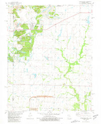
Mindenmines sits at the heart of this borderland survey, where the industry of the Missouri Pacific Railroad meets the extensive environmental reclamation of the Ozark Southwest. The landscape is heavily marked by its industrial heritage, featuring numerous areas labeled as Strip Mine and a Gravel Pit. These former extraction sites have been repurposed into conservation areas like the Mined Land State Wildlife Area and the Lester R. Davis Memorial State Forest, creating a unique topography of ridge-and-hollow terrain and man-made water bodies such as Gardner Farms Lake and Moss Lake.
Find a feature on this map
22 named features on this map. Tap any name to fly to it.
Don’t see what you’re looking for? This feature index may not catch every label — zoom into the map to look around manually.
Map Details
Editions of this 1981 Mindenmines Map
This is the sole edition of this map. No revisions or reprints were ever made.
Other maps of this area

1884 · Fort Scott
USGS Topo · 1:125,000

1886 · Nevada
USGS Topo · 1:125,000

1886 · Joplin
USGS Topo · 1:125,000

1886 · Fort Scott
USGS Topo · 1:125,000

1886 · Carthage
USGS Topo · 1:125,000

1893 · Fort Scott
USGS Topo · 1:125,000

1894 · Nevada
USGS Topo · 1:125,000

1894 · Joplin
USGS Topo · 1:125,000

1894 · Carthage
USGS Topo · 1:125,000

1945 · Pittsburg
USGS Topo · 1:62,500