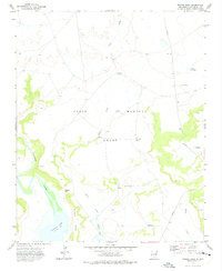
1972 Map of Minese Mesa
USGS Topo · Published 1975About this map
The Pablo Montoya Grant dominates this landscape of the New Mexico high plains, where the Canadian River and its backwaters at Conchas Lake define the western geography. This 1972 survey reveals a terrain shaped by large-scale ranching and water management in a semi-arid environment. The prominence of Minese Mesa and the nearby Minese Gap provide significant landmarks for navigating the draws and creeks that feed the Canadian basin. A network of private ranch roads connects essential water sources such as Lake Windmill, North Pasture Windmill, and Horseshoe Tank, which sustained livestock across the expansive grant lands. Geologic and topographic features like Perra Draw and Tulosa Creek illustrate the natural drainage patterns that have historically dictated human movement and settlement in San Miguel County.
Find a feature on this map
17 named features on this map. Tap any name to fly to it.
Don’t see what you’re looking for? This feature index may not catch every label — zoom into the map to look around manually.
Map Details
Editions of this 1972 Minese Mesa Map
This is the sole edition of this map. No revisions or reprints were ever made.
Other maps of this area

1954 · Santa Fe
USGS Topo · 1:250,000

1958 · Santa Fe
USGS Topo · 1:250,000

1968 · La Cinta Mesa
USGS Topo · 1:24,000

1968 · Conchas Dam
USGS Topo · 1:24,000
1972 · Bell Ranch
USGS Topo · 1:24,000

1972 · Four V Ranch
USGS Topo · 1:24,000

1972 · Arroyo Alamocito
USGS Topo · 1:24,000

1972 · Montoya Point
USGS Topo · 1:24,000

1972 · Waggoner Ranch
USGS Topo · 1:24,000

1972 · Wade Canyon
USGS Topo · 1:24,000