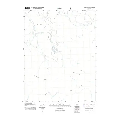
2011 Map of Minnesota Pass
USGS Topo · Published 2011About this map
Minnesota Pass and the surrounding high-country terrain of Delta County are defined by a complex network of alpine drainages and prominent ridges. The hydrography is dominated by the Minnesota Creek system, including its East Fork, South Fork, and Lake Fork branches. These waters originate near massive features such as Mount Gunnison and the Chain Mountains, flowing past landmarks like Beaver Reservoir and its associated Beaver Dam. Human activity is sparse in this landscape, represented by the isolated Upper Cow Camp and County RD 710a. The map highlights the intersection of varied drainage basins, with the North Smith Fork Gunnison River cutting through the southern portion. High-elevation corridors such as Elk Basin Pass and Hoodoo Gap indicate the natural transit points through this portion of the Gunnison National Forest area.
Find a feature on this map
41 named features on this map. Tap any name to fly to it.
Don’t see what you’re looking for? This feature index may not catch every label — zoom into the map to look around manually.
Map Details
Editions of this 2011 Minnesota Pass Map
This is the sole edition of this map. No revisions or reprints were ever made.
Other maps of this area

1938 · Mt. Gunnison
USGS Topo · 1:48,000

1945 · Mount Gunnison
USGS Topo · 1:62,500

1956 · Montrose
USGS Topo · 1:250,000

1959 · Montrose
USGS Topo · 1:250,000

1960 · Montrose
USGS Topo · 1:250,000
1964 · West Beckwith Peak
USGS Topo · 1:24,000
1964 · Paonia Reservoir
USGS Topo · 1:24,000

1964 · Minnesota Pass
USGS Topo · 1:24,000
1964 · Somerset
USGS Topo · 1:24,000

1965 · Mount Guero
USGS Topo · 1:24,000