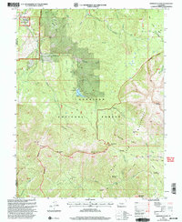
2001 Map of Minnesota Pass
USGS Topo · Published 2004About this map
The high alpine transitions of the West Elk Mountains define this 2001 revision, where the Gunnison National Forest meets the protected reaches of the West Elk Wilderness. The landscape is shaped by the drainage systems of Minnesota Creek and the Smith Fork, providing a detailed view of the water resources managed at Beaver Reservoir. Traditional land use is evident through the presence of high-altitude outposts like Upper Cow Camp and Minnesota Cow Camp, which speak to the area's history of seasonal grazing.
Find a feature on this map
44 named features on this map. Tap any name to fly to it.
Don’t see what you’re looking for? This feature index may not catch every label — zoom into the map to look around manually.
Map Details
Editions of this 2001 Minnesota Pass Map
This is the sole edition of this map. No revisions or reprints were ever made.
Other maps of this area

1938 · Mt. Gunnison
USGS Topo · 1:48,000

1945 · Mount Gunnison
USGS Topo · 1:62,500

1956 · Montrose
USGS Topo · 1:250,000

1959 · Montrose
USGS Topo · 1:250,000

1960 · Montrose
USGS Topo · 1:250,000
1964 · West Beckwith Peak
USGS Topo · 1:24,000
1964 · Paonia Reservoir
USGS Topo · 1:24,000

1964 · Minnesota Pass
USGS Topo · 1:24,000
1964 · Somerset
USGS Topo · 1:24,000

1965 · Mount Guero
USGS Topo · 1:24,000