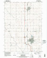
1995 Map of Minonk
USGS Topo · Published 1996About this map
The town of Minonk serves as the central hub of this mid-1990s survey, where the convergence of rail lines and agricultural transport defines the local economy. Traces of the region's industrial past are visible in the form of a Mine Dump near Rutland, reflecting a landscape once shaped by coal extraction before it fully transitioned to intensive farming. The infrastructure for crop dusting and local aviation is evident through private facilities like Hattan Farms Landing Strip and the Oltman-Shuck Landing Strips south of town. For genealogists, the map provides precise locations for several regional burial grounds, including St Patricks Cem, Minonk Township Cem, and Rutland Cem. The drainage patterns of the North Branch Crow Creek and South Branch Crow Creek weave through the townships of Bennington and Clayton, illustrating how the waterway system dictated early settlement and land division across the Woodford and Marshall county lines.
Find a feature on this map
31 named features on this map. Tap any name to fly to it.
Don’t see what you’re looking for? This feature index may not catch every label — zoom into the map to look around manually.
Map Details
Editions of this 1995 Minonk Map
This is the sole edition of this map. No revisions or reprints were ever made.
Other maps of this area

1925 · Streator
USGS Topo · 1:62,500

1927 · Streator
USGS Topo · 1:62,500

1934 · Wenona
USGS Topo · 1:48,000

1939 · Wenona
USGS Topo · 1:62,500

1955 · Minonk
USGS Topo · 1:62,500

1958 · Flanagan
USGS Topo · 1:62,500

1958 · Aurora
USGS Topo · 1:250,000

1958 · Peoria
USGS Topo · 1:250,000

1961 · Aurora
USGS Topo · 1:250,000

1961 · Peoria
USGS Topo · 1:250,000