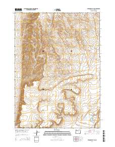
2014 Map of Miranda Flat SE
USGS Topo · Published 2014About this map
Harney County's high desert landscape is defined by its Public Land Survey System grid in this 2014 topographic study. The map area is divided into several townships, including T34s R35e, T34s R36e, T35s R35e, and T35s R36e. These divisions reflect the systematic 19th-century organization of the American West, which continues to govern modern land ownership and resource management in eastern Oregon. The terrain is marked by intricate contour lines that reveal the complex drainage patterns and elevation shifts characteristic of the Oregon desert, providing a base for understanding the region's ranching history and natural environment.
Find a feature on this map
4 named features on this map. Tap any name to fly to it.
Don’t see what you’re looking for? This feature index may not catch every label — zoom into the map to look around manually.
Map Details
Editions of this 2014 Miranda Flat SE Map
This is the sole edition of this map. No revisions or reprints were ever made.
Other maps of this area

1955 · Adel
USGS Topo · 1:250,000

1957 · Adel
USGS Topo · 1:250,000

1958 · Adel
USGS Topo · 1:250,000

1962 · Adel
USGS Topo · 1:250,000

1981 · Coyote Lake West
USGS Topo · 1:24,000

1981 · Tule Springs
USGS Topo · 1:24,000

1981 · Tule Springs NE
USGS Topo · 1:24,000

1981 · Ancient Lake Well
USGS Topo · 1:24,000

1981 · Miranda Flat SW
USGS Topo · 1:24,000

1981 · Miranda Flat SE
USGS Topo · 1:24,000