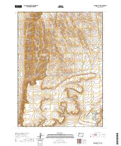
2020 Map of Miranda Flat SE
USGS Topo · Published 2020About this map
The high desert landscape of Harney County is defined by the Public Land Survey System grid, which organizes this undeveloped section of southeastern Oregon. The map area is primarily composed of the intersection of four township and range blocks: T34s R35e, T34s R36e, T35s R36e, and T35s R35e. This terrain is characterized by intricate contour lines that reveal a complex network of dry washes and high-elevation ridges typical of the northern Great Basin. There are no named settlements or human-made structures printed on this specific 2020 edition, making it a primary resource for visualizing the raw topography of the Oregon backcountry before any modern development or to study the precise land divisions used by the Bureau of Land Management.
Find a feature on this map
4 named features on this map. Tap any name to fly to it.
Don’t see what you’re looking for? This feature index may not catch every label — zoom into the map to look around manually.
Map Details
Editions of this 2020 Miranda Flat SE Map
This is the sole edition of this map. No revisions or reprints were ever made.
Other maps of this area

1955 · Adel
USGS Topo · 1:250,000

1957 · Adel
USGS Topo · 1:250,000

1958 · Adel
USGS Topo · 1:250,000

1962 · Adel
USGS Topo · 1:250,000

1981 · Coyote Lake West
USGS Topo · 1:24,000

1981 · Tule Springs
USGS Topo · 1:24,000

1981 · Tule Springs NE
USGS Topo · 1:24,000

1981 · Ancient Lake Well
USGS Topo · 1:24,000

1981 · Miranda Flat SW
USGS Topo · 1:24,000

1981 · Miranda Flat SE
USGS Topo · 1:24,000