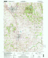
2000 Map of Mitchell
USGS Topo · Published 2001About this map
Spring Mill Village and the surrounding Spring Mill State Park anchor the northern landscape of this Lawrence County and Orange County border region. This survey highlights the complex drainage patterns of the Lost River and Fishing Creek, reflecting the area's karst-influenced topography. The map illustrates a developed mid-century infrastructure, featuring the CSX Transportation rail line and the diagonal line of the Indian Treaty Boundary cutting across the terrain north of Orleans. Local community life is documented through numerous landmarks, including Union Chapel, the Burris School, and a Drive-in Theater near Mitchell. Genealogists can locate several burial sites such as Fairview Cem and Old Cem, while the presence of a Quarry and Storage Bins points to the local industrial and agricultural economy.
Find a feature on this map
27 named features on this map. Tap any name to fly to it.
Don’t see what you’re looking for? This feature index may not catch every label — zoom into the map to look around manually.
Map Details
Editions of this 2000 Mitchell Map
This is the sole edition of this map. No revisions or reprints were ever made.
Other maps of this area

1934 · Bedford
USGS Topo · 1:48,000

1935 · Oolitic
USGS Topo · 1:48,000

1937 · Bedford
USGS Topo · 1:62,500

1942 · Oolitic
USGS Topo · 1:62,500

1949 · Georgia
USGS Topo · 1:24,000

1950 · Mitchell
USGS Topo · 1:24,000

1951 · French Lick
USGS Topo · 1:24,000

1951 · Georgia
USGS Topo · 1:24,000

1956 · Vincennes
USGS Topo · 1:250,000

1957 · Vincennes
USGS Topo · 1:250,000