
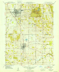
1950 Map of Mitchell
USGS Topo · Published 1950About this map
The Chicago Indianapolis and Louisville and Baltimore and Ohio railroads intersect at Mitchell, anchoring the mid-century industrial and transport landscape of southern Indiana. This 1950 survey reveals a region defined by its unique subterranean geography, where the Lost River disappears into the limestone and notable caverns like Hamer Cave, Donaldson Cave, and Twin Caves cluster within Spring Mill State Park. The map documents the restored Spring Mill Village and the nearby Purdue Experimental Orchard, illustrating the area's mix of historical preservation and agricultural research. Further south, the town of Orleans is plotted along the Second Principal Meridian, surrounded by rural landmarks such as Liberty Ch and Union Chapel, which serve as vital reference points for local family history and land tenure studies.
Find a feature on this map
30 named features on this map. Tap any name to fly to it.
Don’t see what you’re looking for? This feature index may not catch every label — zoom into the map to look around manually.
Map Details
Editions of this 1950 Mitchell Map
2 editions found
Other maps of this area

1934 · Bedford
USGS Topo · 1:48,000

1935 · Oolitic
USGS Topo · 1:48,000

1937 · Bedford
USGS Topo · 1:62,500

1942 · Oolitic
USGS Topo · 1:62,500

1949 · Georgia
USGS Topo · 1:24,000

1951 · French Lick
USGS Topo · 1:24,000

1951 · Georgia
USGS Topo · 1:24,000

1956 · Vincennes
USGS Topo · 1:250,000

1957 · Vincennes
USGS Topo · 1:250,000
1957 · Bedford West
USGS Topo · 1:24,000