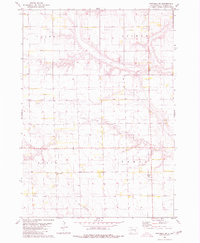
1980 Map of Mitchell SW
USGS Topo · Published 1980About this map
Twelvemile Creek winds through the rural landscape of Davison County, defining the drainage patterns across the townships of Union, Lisbon, Baker, and Tobin. This 1980 survey captures the agricultural character of South Dakota as it appeared in the late 1970s, documented through precise photogrammetric methods. The map is particularly useful for genealogists, as it identifies small local burial sites like the Church of God Cem and the Townhall Emsley Cem, which serve as vital markers of early community life in these sections. The transition between Twelvemile Creek and its southern branch, Twelvemile Cr, illustrates the subtle topography of the Great Plains, where even slight elevation changes dictated the placement of roads and farmsteads.
Find a feature on this map
10 named features on this map. Tap any name to fly to it.
Don’t see what you’re looking for? This feature index may not catch every label — zoom into the map to look around manually.
Map Details
Editions of this 1980 Mitchell SW Map
This is the sole edition of this map. No revisions or reprints were ever made.
Other maps of this area

1899 · Mitchell
USGS Topo · 1:125,000

1955 · Mitchell
USGS Topo · 1:250,000

1957 · Mitchell
USGS Topo · 1:24,000

1959 · Mitchell
USGS Topo · 1:250,000
1979 · Delmont NE
USGS Topo · 1:24,000
1979 · Hillside
USGS Topo · 1:24,000

1980 · Corsica Lake
USGS Topo · 1:24,000

1980 · Old Stickney Lake
USGS Topo · 1:24,000
1980 · Shoemaker Dam
USGS Topo · 1:24,000

1980 · Mount Vernon
USGS Topo · 1:24,000