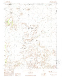
1988 Map of Mitten Buttes
USGS Topo · Published 1988About this map
The Navajo Indian Reservation landscape is defined by its iconic spires and plateaus on this late-twentieth-century study of the Arizona and Utah border. Dominating the northern horizon, the towering formations of West Mitten Butte and East Mitten Butte stand alongside Merrick Butte, marking the distinct topography of the region. The map documents a sophisticated network of named geological landmarks that were already world-renowned at the time of the 1988 field check, including Elephant Butte, the Three Sisters, and Spearhead Mesa.
Find a feature on this map
42 named features on this map. Tap any name to fly to it.
Don’t see what you’re looking for? This feature index may not catch every label — zoom into the map to look around manually.
Map Details
Editions of this 1988 Mitten Buttes Map
This is the sole edition of this map. No revisions or reprints were ever made.
Other maps of this area

1883 · Marsh Pass
USGS Topo · 1:250,000

1886 · Henry Mountains
USGS Topo · 1:250,000

1886 · Abajo
USGS Topo · 1:250,000

1892 · Marsh Pass
USGS Topo · 1:250,000

1892 · Abajo
USGS Topo · 1:250,000

1892 · Henry Mountains
USGS Topo · 1:250,000

1892 · Canyon De Chelly
USGS Topo · 1:250,000

1893 · Abajo
USGS Topo · 1:250,000

1952 · Clay Hills 4 SW
USGS Topo · 1:24,000

1952 · Agathla Peak 1 NW
USGS Topo · 1:24,000