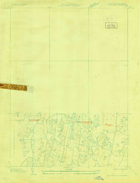
1928 Map of Mittineague
USGS Topo · Published 1928About this map
The Massachusetts Connecticut state line bisects this 1928 aerial compilation, illustrating the borderlands between Suffield and the northern towns of Southwick and Agawam. This advance sheet, based on U.S. Army Air Corps photography from the late 1920s, documents a landscape of agricultural fields and woodlots before significant suburban expansion. The N Y N H & H railroad cuts a straight north-south path through the center, crossing the Hampden Co Hartford Co boundary near where Still Brook drains the lowlands. While much of the sheet remains blank as an early-stage study, the southern portion provides a precise look at the rural roads and terrain around Buck Hill during the final years of the pre-Depression era.
Find a feature on this map
10 named features on this map. Tap any name to fly to it.
Don’t see what you’re looking for? This feature index may not catch every label — zoom into the map to look around manually.
Map Details
Editions of this 1928 Mittineague Map
This is the sole edition of this map. No revisions or reprints were ever made.
Other maps of this area

1886 · Springfield
USGS Topo · 1:62,500

1887 · Granville
USGS Topo · 1:62,500

1889 · Springfield
USGS Topo · 1:62,500

1889 · Granville
USGS Topo · 1:62,500

1892 · Hartford
USGS Topo · 1:62,500

1892 · Granby
USGS Topo · 1:62,500

1893 · Springfield
USGS Topo · 1:62,500

1893 · Granville
USGS Topo · 1:62,500

1895 · Springfield
USGS Topo · 1:62,500

1895 · Granville
USGS Topo · 1:62,500