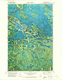
1971 Map of Mizpah NE
USGS Topo · Published 1974About this map
Pine Island State Forest dominates this Koochiching County landscape, as documented in this 1971 orthophotomap. The settlement of Gemmell is visible in the northwest, situated along the corridor of Route 71 and the Gemmell Road. This specific edition uses a photographic base to reveal the intricate texture of the Minnesota wetlands and timberlands, providing a clear view of how human activity such as Gravel Pits and a small Cem intersect with the natural drainage systems. The hydrography is particularly detailed, featuring the winding path of Caldwell Brook and Pancake Creek, which feed into the larger Lost River system. The proximity of Clear Lake and Dark Lake highlights the varied aquatic features of the region, while the presence of established section lines and township boundaries like T. 152 N. and T. 151 N. helps genealogists and land researchers pinpoint specific historical property locations within the forest.
Find a feature on this map
12 named features on this map. Tap any name to fly to it.
Don’t see what you’re looking for? This feature index may not catch every label — zoom into the map to look around manually.
Map Details
Editions of this 1971 Mizpah NE Map
This is the sole edition of this map. No revisions or reprints were ever made.
Other maps of this area

1918 · Zora
USGS Topo · 1:62,500

1919 · Zora
USGS Topo · 1:62,500

1919 · Lundgren
USGS Topo · 1:62,500

1919 · Gemmell
USGS Topo · 1:62,500

1919 · Margie
USGS Topo · 1:62,500

1954 · Bemidji
USGS Topo · 1:250,000

1954 · Hibbing
USGS Topo · 1:250,000

1954 · Roseau
USGS Topo · 1:250,000

1954 · International Falls
USGS Topo · 1:250,000

1957 · Roseau
USGS Topo · 1:250,000