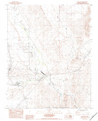
1983 Map of Moapa East
USGS Topo · Published 1983About this map
Moapa and Glendale anchor this early 1980s look at the desert landscape where the Muddy River meets major infrastructure. The town of Moapa is situated along the Union Pacific railroad corridor, while Glendale marks a junction of roadways and transmission lines. The hydrological character of the region is defined by the Meadow Valley Wash, protected in parts by a Levee, and the California Wash entering from the southwest. Local operations are evident at Searles Ranch and a nearby Gravel Pit. Aviation and communication landmarks, including a Landing Strip, a Radio Facility, and an Airway Beacon, indicate the area's importance as a transit and utility corridor. The terrain transitions into the North Muddy Mountains to the south, featuring Weiser Ridge and the dramatic topographic pinch point known as The Narrows.
Find a feature on this map
24 named features on this map. Tap any name to fly to it.
Don’t see what you’re looking for? This feature index may not catch every label — zoom into the map to look around manually.
Map Details
Editions of this 1983 Moapa East Map
This is the sole edition of this map. No revisions or reprints were ever made.
Other maps of this area

1886 · Saint Thomas
USGS Topo · 1:250,000

1893 · Saint Thomas
USGS Topo · 1:250,000

1954 · Las Vegas
USGS Topo · 1:250,000

1957 · Las Vegas
USGS Topo · 1:250,000

1958 · Moapa
USGS Topo · 1:62,500

1958 · Overton
USGS Topo · 1:62,500

1959 · Las Vegas
USGS Topo · 1:250,000

1962 · Las Vegas
USGS Topo · 1:250,000

1969 · Farrier
USGS Topo · 1:24,000
1969 · Rox SE
USGS Topo · 1:24,000