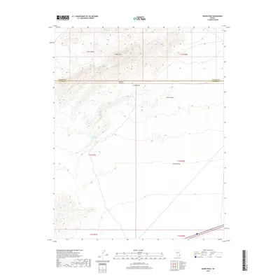
2018 Map of Moapa Peak
USGS Topo · Published 2018About this map
Moapa Peak stands as the dominant topographical landmark in this high desert landscape, located where the Mormon Mountains meet the southern border of Lincoln County. The map details a transition from the elevated peaks in the north, including the secluded Jacks Pockets, down toward the expansive flatlands of the Mojave Desert and the high, level plateau of Mormon Mesa. Water management in this arid environment is evidenced by the Sheep Canyon Reservoir, a critical feature for land use in the eastern reaches of Clark County. The survey illustrates the stark geographic divide between the mountainous northern terrain and the broad alluvial plains that define the southeastern Nevada wilderness during this era.
Find a feature on this map
13 named features on this map. Tap any name to fly to it.
Don’t see what you’re looking for? This feature index may not catch every label — zoom into the map to look around manually.
Map Details
Editions of this 2018 Moapa Peak Map
This is the sole edition of this map. No revisions or reprints were ever made.
Other maps of this area

1886 · Saint Thomas
USGS Topo · 1:250,000

1893 · Saint Thomas
USGS Topo · 1:250,000

1954 · Las Vegas
USGS Topo · 1:250,000

1957 · Las Vegas
USGS Topo · 1:250,000

1958 · Moapa
USGS Topo · 1:62,500

1958 · Overton
USGS Topo · 1:62,500

1959 · Las Vegas
USGS Topo · 1:250,000

1962 · Las Vegas
USGS Topo · 1:250,000
1969 · Rox NE
USGS Topo · 1:24,000
1969 · Rox SE
USGS Topo · 1:24,000