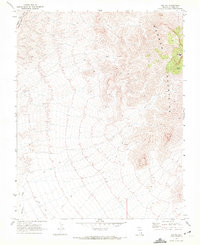
1969 Map of Rox NE
USGS Topo · Published 1972About this map
Mormon Mountains dominate the eastern landscape of this Lincoln County survey, rising toward the prominent Mormon Peak. This high desert terrain is punctuated by intermittent water sources like Davies Spring and drainage systems including Meadow Valley Wash and Whitmore Wash. Human activity in the late 1960s was primarily concentrated along the western edge, where the Union Pacific railroad tracks cut through the valley. Evidence of earlier exploration and resource extraction is visible through scattered prospect sites and an isolated Ruin located within the mountain range. A network of jeep trails and smaller trails provides the only access into the complex topography of the range, reflecting a period of mining interest and remote ranching infrastructure in the Nevada wilderness.
Find a feature on this map
10 named features on this map. Tap any name to fly to it.
Don’t see what you’re looking for? This feature index may not catch every label — zoom into the map to look around manually.
Map Details
Editions of this 1969 Rox NE Map
2 editions found
Other maps of this area

1885 · Pioche
USGS Topo · 1:250,000

1886 · Saint Thomas
USGS Topo · 1:250,000

1886 · Pioche
USGS Topo · 1:250,000

1893 · Saint Thomas
USGS Topo · 1:250,000

1954 · Caliente
USGS Topo · 1:250,000

1954 · Las Vegas
USGS Topo · 1:250,000

1957 · Las Vegas
USGS Topo · 1:250,000

1959 · Caliente
USGS Topo · 1:250,000

1959 · Las Vegas
USGS Topo · 1:250,000

1962 · Las Vegas
USGS Topo · 1:250,000