
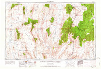
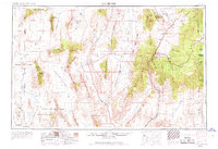
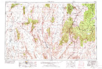
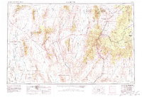
1954 Map of Caliente
USGS Topo · Published 1954About this map
The Union Pacific railroad cuts a vital corridor through Lincoln County's basin and range topography, anchoring rail stops like Caliente and Acoma during the mid-1950s. Mining activity is central to the local economy, evidenced by the Prince Mine near Pioche and the established town of Delamar within its namesake mountains. This survey illustrates a landscape of extreme contrast, where agricultural settlements like Alamo and Hiko in the Pahranagat Valley sit in the shadow of massive military tracts.
Find a feature on this map
99 named features on this map. Tap any name to fly to it.
Don’t see what you’re looking for? This feature index may not catch every label — zoom into the map to look around manually.
Map Details
Editions of this 1954 Caliente Map
5 editions found
Other maps of this area

1885 · St. George
USGS Topo · 1:250,000

1885 · Pioche
USGS Topo · 1:250,000

1886 · Saint Thomas
USGS Topo · 1:250,000

1886 · Mt. Trumbull
USGS Topo · 1:250,000

1886 · Pioche
USGS Topo · 1:250,000

1891 · St. George
USGS Topo · 1:250,000

1892 · Mt. Trumbull
USGS Topo · 1:250,000

1893 · Saint Thomas
USGS Topo · 1:250,000

1907 · Las Vegas
USGS Topo · 1:250,000

1908 · Kawich
USGS Topo · 1:250,000