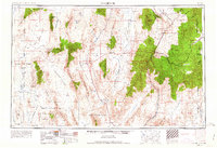
1954 Map of Caliente
USGS Topo · Published 1963About this map
Caliente and the railroad stop of Panaca anchor this high-desert landscape in southeastern Nevada, where the Union Pacific line snakes through the Meadow Valley Mountains. The map reveals an era of strategic military expansion and mining activity, with the western portion dominated by the Nellis Air Force Range and the Slanted Butte Test Site. In the east, the historic mining district near Pioche is well-documented, featuring the Freeburg Mine and Lincoln Mine alongside the company towns of Prince and Caselton. This 1950s record provides a clear look at the valley-and-range topography before major modern developments, identifying essential water sources like Ash Springs and Upper Pahranagat Lake that sustained early ranches and settlements. Notable recreation sites such as Cathedral Gorge State Park and the Desert Game Range highlight the region's early conservation efforts amid its industrial and military priorities.
Find a feature on this map
85 named features on this map. Tap any name to fly to it.
Don’t see what you’re looking for? This feature index may not catch every label — zoom into the map to look around manually.
Map Details
Editions of this 1954 Caliente Map
5 editions found

Other maps of this area

1885 · St. George
USGS Topo · 1:250,000

1885 · Pioche
USGS Topo · 1:250,000

1886 · Saint Thomas
USGS Topo · 1:250,000

1886 · Mt. Trumbull
USGS Topo · 1:250,000

1886 · Pioche
USGS Topo · 1:250,000

1891 · St. George
USGS Topo · 1:250,000

1892 · Mt. Trumbull
USGS Topo · 1:250,000

1893 · Saint Thomas
USGS Topo · 1:250,000

1907 · Las Vegas
USGS Topo · 1:250,000

1908 · Kawich
USGS Topo · 1:250,000