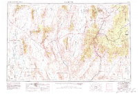
1954 Map of Caliente
USGS Topo · Published 1980About this map
Pioche and the surrounding mining districts anchor this mid-century survey of Lincoln County, Nevada. The landscape is defined by the heavy infrastructure of the Union Pacific railroad, which threads through the Meadow Valley to serve settlements like Caliente and Panaca. To the west, the map documents the expansive Nellis Air Force Range, featuring landmarks such as Groom Mine and Fallout Hills, alongside the specialized designations of Plutonium Valley. This era shows a region balanced between traditional ranching and mining roots and the growing footprint of federal military and conservation efforts. Water sources remain critical to the area's geography, noted at Pahranagat Lake and the various thermal features at Ash Springs and Crystal Springs. The eastern edge captures the border with Utah, marking the transition from the high desert ranges into the Clover Mountains.
Find a feature on this map
106 named features on this map. Tap any name to fly to it.
Don’t see what you’re looking for? This feature index may not catch every label — zoom into the map to look around manually.
Map Details
Editions of this 1954 Caliente Map
5 editions found

Other maps of this area

1885 · St. George
USGS Topo · 1:250,000

1885 · Pioche
USGS Topo · 1:250,000

1886 · Saint Thomas
USGS Topo · 1:250,000

1886 · Mt. Trumbull
USGS Topo · 1:250,000

1886 · Pioche
USGS Topo · 1:250,000

1891 · St. George
USGS Topo · 1:250,000

1892 · Mt. Trumbull
USGS Topo · 1:250,000

1893 · Saint Thomas
USGS Topo · 1:250,000

1907 · Las Vegas
USGS Topo · 1:250,000

1908 · Kawich
USGS Topo · 1:250,000