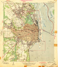
1943 Map of Mobile
USGS Topo · Published 1943About this map
The Mobile River waterfront and its complex of State Docks anchor this wartime survey, showing the city's critical role as a port and rail hub. Just west of the Bankhead Tunnel, the grid of downtown Mobile transitions into historic neighborhoods and industrial centers like Prichard and Plateau. The map documents a dense social infrastructure, from the sprawling Magnolia Cemetery and Oak Hill Golf Course to numerous local institutions such as Murphy High Sch and the Visitation Convent. Beyond the urban core, the landscape gives way to wetlands and bayous including Hog Bayou and the winding course of Three Mile Creek. The presence of the Gulf Mobile and Ohio RR and the Louisville and Nashville RR illustrates how the city’s economy was tightly woven between deep-water shipping lanes and the extensive rail networks of the mid-twentieth century.
Find a feature on this map
93 named features on this map. Tap any name to fly to it.
Don’t see what you’re looking for? This feature index may not catch every label — zoom into the map to look around manually.
Map Details
Editions of this 1943 Mobile Map
2 editions found
Other maps of this area

1921 · Fairhope
USGS Topo · 1:62,500

1922 · Mobile
USGS Topo · 1:62,500

1939 · Daphne
USGS Topo · 1:31,680

1940 · Hollingers Island
USGS Topo · 1:31,680

1940 · Mobile
USGS Topo · 1:31,680

1940 · Mobile
USGS Topo · 1:62,500

1941 · Chickasaw
USGS Topo · 1:31,680

1941 · Daphne
USGS Topo · 1:31,680

1941 · Blakeley
USGS Topo · 1:31,680

1941 · Bay Minette
USGS Topo · 1:62,500