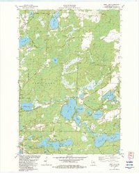
1982 Map of Moen Lake
USGS Topo · Published 1983About this map
The Soo Line tracks cut through this northwoods landscape, connecting the small settlements of Roosevelt and Starks during the early 1980s. This territory is defined by an intricate network of glacial lakes and wetlands, including the prominent chain of Moen Lake, Second Lake, Third Lake, Fourth Lake, and Fifth Lake. Cultural landmarks like the Foursquare Ch, Northland Memorial Park, and a Drive-in Theater are interspersed with the industrial signatures of several Gravel Pits and a Slaughterhouse. Evidence of older transportation routes persists in the form of an Old Railroad Grade north of Webber Creek. Aviation history is noted at the Sowinski Landing Field in the northeast, while the eastern edge shows the transition into the Starks Flowage and Tenderfoot Lake area, reflecting the region's managed water systems and recreational character.
Find a feature on this map
64 named features on this map. Tap any name to fly to it.
Don’t see what you’re looking for? This feature index may not catch every label — zoom into the map to look around manually.
Map Details
Editions of this 1982 Moen Lake Map
This is the sole edition of this map. No revisions or reprints were ever made.
Other maps of this area

1928 · Three Lakes
USGS Topo · 1:48,000

1930 · Robbins
USGS Topo · 1:48,000

1938 · Three Lakes
USGS Topo · 1:48,000

1938 · Robbins
USGS Topo · 1:48,000

1940 · Monico
USGS Topo · 1:48,000

1940 · Rhinelander
USGS Topo · 1:48,000

1945 · Three Lakes
USGS Topo · 1:48,000

1945 · Robbins
USGS Topo · 1:48,000

1949 · Rhinelander
USGS Topo · 1:48,000

1950 · Monico
USGS Topo · 1:48,000