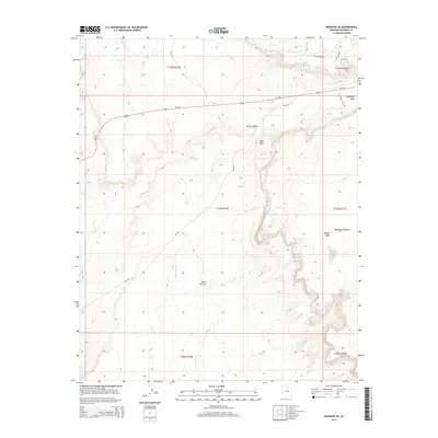
2014 Map of Moenave SE
USGS Topo · Published 2014About this map
Tuba Arch stands as a prominent natural landmark within this high-desert landscape, situated just south of the Kerley Valley. The terrain is defined by dramatic elevation shifts, ranging from the low-lying Fivemile Wash to the expansive heights of the Moenkopi Plateau and Tohnali Mesa. This 2014 survey documents a network of Bureau of Indian Affairs routes and federal highways that provide access to these remote reaches, including Us-160 and Bia-6731. The presence of water sources like Billy Spring and the drainage of Moenkopi Wash are critical features in this arid environment, influencing the historical positioning of roads and cattle trails across Ward Terrace. The map captures a transitional period of modern infrastructure overlaying traditional land features such as Toh Nee Di Kishi.
Find a feature on this map
22 named features on this map. Tap any name to fly to it.
Don’t see what you’re looking for? This feature index may not catch every label — zoom into the map to look around manually.
Map Details
Editions of this 2014 Moenave SE Map
This is the sole edition of this map. No revisions or reprints were ever made.
Other maps of this area

1886 · San Francisco Mtns
USGS Topo · 1:250,000

1886 · Echo Cliffs
USGS Topo · 1:250,000

1891 · San Francisco Mtns
USGS Topo · 1:250,000

1891 · Echo Cliffs
USGS Topo · 1:250,000

1894 · San Francisco Mtns
USGS Topo · 1:250,000

1899 · San Francisco Mtns
USGS Topo · 1:250,000

1947 · Flagstaff
USGS Topo · 1:250,000

1954 · Flagstaff
USGS Topo · 1:250,000

1955 · Moa Ave NW
USGS Topo · 1:24,000
1955 · Moa Ave SW
USGS Topo · 1:24,000