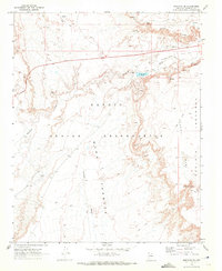
1969 Map of Moenave SE
USGS Topo · Published 1972About this map
Navajo Indian Reservation lands dominate this high-desert landscape in Coconino County, characterized by the stark transition from the Kerley Valley to the elevated Moenkopi Plateau. The terrain is defined by the winding course of Moenkopi Wash, which cuts through the center of the sheet near Ward Terrace. A series of perennial and seasonal water sources, including Billy Spring and the named water hole Toh Nee Di Kishi, emphasize the importance of water management in this arid region. Man-made infrastructure of the late 1960s is evident in the inclusion of Sewage Disposal Ponds, a Radio Facility, and scattered Borrow Pits. An extensive network of Jeep Trails provides the primary means of navigation across the mesas and through the many unnamed springs that dot the canyon walls.
Find a feature on this map
20 named features on this map. Tap any name to fly to it.
Don’t see what you’re looking for? This feature index may not catch every label — zoom into the map to look around manually.
Map Details
Editions of this 1969 Moenave SE Map
This is the sole edition of this map. No revisions or reprints were ever made.
Other maps of this area

1886 · San Francisco Mtns
USGS Topo · 1:250,000

1886 · Echo Cliffs
USGS Topo · 1:250,000

1891 · San Francisco Mtns
USGS Topo · 1:250,000

1891 · Echo Cliffs
USGS Topo · 1:250,000

1894 · San Francisco Mtns
USGS Topo · 1:250,000

1899 · San Francisco Mtns
USGS Topo · 1:250,000

1947 · Flagstaff
USGS Topo · 1:250,000

1954 · Flagstaff
USGS Topo · 1:250,000

1955 · Moa Ave NW
USGS Topo · 1:24,000
1955 · Moa Ave SW
USGS Topo · 1:24,000