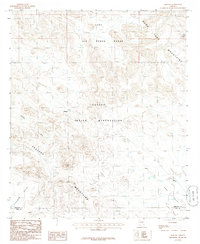
1986 Map of Moivayi
USGS Topo · Published 1986About this map
The Papago Indian Reservation dominates this desert landscape in the mid-1980s, revealing a sparse network of settlements and seasonal waterways. The small community of Moivayi sits near a marked Cem, while the settlement of Kaka is situated further south where the Kaka Valley opens up. The terrain is defined by the high ridges of the Sand Tank Mountains and the Sauceda Mountains, which channel drainage into ephemeral features like Sand Tank Wash and Sauceda Wash. In the northern portion of the quadrangle, the Luke Air Force Range overlaps the reservation lands, marking a significant intersection of federal and tribal administrative boundaries. This survey provides a precise look at the arid Hickiwan Valley as it appeared before major regional shifts in naming and land management.
Find a feature on this map
13 named features on this map. Tap any name to fly to it.
Don’t see what you’re looking for? This feature index may not catch every label — zoom into the map to look around manually.
Map Details
Editions of this 1986 Moivayi Map
This is the sole edition of this map. No revisions or reprints were ever made.
Other maps of this area

1953 · Ajo
USGS Topo · 1:250,000

1957 · Ajo
USGS Topo · 1:250,000

1958 · Ajo
USGS Topo · 1:250,000

1958 · Kaka
USGS Topo · 1:62,500

1958 · Hat Mountain
USGS Topo · 1:62,500

1962 · Ajo
USGS Topo · 1:250,000

1963 · Ajo
USGS Topo · 1:250,000

1963 · Sikort Chuapo Mts
USGS Topo · 1:62,500

1963 · Cimarron Peak
USGS Topo · 1:62,500

1967 · Ajo
USGS Topo · 1:250,000