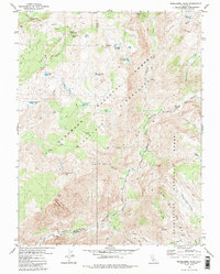
1979 Map of Mokelumne Peak
USGS Topo · Published 1986About this map
Mokelumne Peak stands as the central landmark in this high-elevation mountain landscape, where the borders of Amador, Alpine, and Calaveras counties converge within the Mokelumne Wilderness. The area is characterized by a network of seasonal water sources and meadows, including Ladeux Meadow and Munson Meadow, which historically supported early alpine travel and livestock. Traces of pioneer-era transit are evident at the Plasse Trading Post (Site), located near Plasse and a designated Cem and Grave, indicating the human toll of mountain passage. The terrain is deeply incised by the North Fork Mokelumne River and rugged drainages like Fourth of July Canyon. Notable high-country camps such as Camp Irene and Cedar Camp appear alongside established routes like the Squaw Ridge boundary, marking this as a documented corridor for wilderness surveying and recreational pack travel in the late 1970s.
Find a feature on this map
47 named features on this map. Tap any name to fly to it.
Don’t see what you’re looking for? This feature index may not catch every label — zoom into the map to look around manually.
Map Details
Editions of this 1979 Mokelumne Peak Map
3 editions found
Other maps of this area

1889 · Pyramid Peak
USGS Topo · 1:125,000

1889 · Markleeville
USGS Topo · 1:125,000

1891 · Markleeville
USGS Topo · 1:125,000

1891 · Big Trees
USGS Topo · 1:125,000

1891 · Pyramid Peak
USGS Topo · 1:125,000

1893 · Markleeville
USGS Topo · 1:125,000

1894 · Big Trees
USGS Topo · 1:125,000

1895 · Pyramid Peak
USGS Topo · 1:125,000

1896 · Dardanelles
USGS Topo · 1:125,000

1896 · Pyramid Peak
USGS Topo · 1:125,000