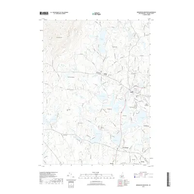
2018 Map of Monadnock Mountain
USGS Topo · Published 2018About this map
Amos Fortune Graves and the Hannah Davis Graves reflect the deep local history of Jaffrey Center, where the Old Center Cem and Cutler Cem stand near the base of the prominent Monadnock Mtn. This area of Cheshire County is defined by its glacial hydrology, featuring a dense network of water bodies including Thorndike Pond, Gilmore Pond, and the wide Contoocook Lake near Woodmere. In the southern portion of the quadrangle, the campus of Franklin Pierce Univ sits overlooking Pearly Lake, while the village of Rindge and West Rindge mark the transition toward the Massachusetts border. The landscape is a mosaic of wooded hills like Peabody Hill and low-lying wetlands such as Dead Swamp and Cummings Meadow, connected by a winding network of rural roads that bypass the larger peaks of the Monadnock range.
Find a feature on this map
130 named features on this map. Tap any name to fly to it.
Don’t see what you’re looking for? This feature index may not catch every label — zoom into the map to look around manually.
Map Details
Editions of this 2018 Monadnock Mountain Map
This is the sole edition of this map. No revisions or reprints were ever made.
Other maps of this area

1887 · Winchendon
USGS Topo · 1:62,500

1887 · Fitchburg
USGS Topo · 1:62,500

1889 · Fitchburg
USGS Topo · 1:62,500

1890 · Winchendon
USGS Topo · 1:62,500

1893 · Fitchburg
USGS Topo · 1:62,500

1894 · Winchendon
USGS Topo · 1:62,500

1898 · Monadnock
USGS Topo · 1:62,500

1900 · Peterboro
USGS Topo · 1:62,500

1931 · Fitchburg
USGS Topo · 1:48,000

1932 · Winchendon
USGS Topo · 1:48,000