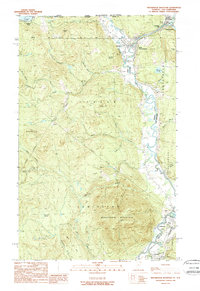
1989 Map of Monadnock Mountain
USGS Topo · Published 1989About this map
Monadnock Mountain dominates the southern landscape of this Vermont and New Hampshire border region, where the Connecticut River carves a winding path between Essex Co and Coos Co. This late-twentieth-century study documents the international boundary between Canada and the United States, marked by numerous survey monuments such as Mon 87. The river acts as a central artery for small-town life, connecting Beecher Falls and West Stewartstown in the north to the larger settlement of Colebrook downstream. Local geography is defined by family-named landmarks and rural infrastructure, including Harriman Hill, the Waste Treatment Plant, and a Gravel Pit near Columbia. Tributaries like Leach Creek and Willard Stream feed into the main river valley, while higher elevations are punctuated by peaks like Van Dyke Mountain and the swampy depressions of Meacham Swamp.
Find a feature on this map
74 named features on this map. Tap any name to fly to it.
Don’t see what you’re looking for? This feature index may not catch every label — zoom into the map to look around manually.
Map Details
Editions of this 1989 Monadnock Mountain Map
This is the sole edition of this map. No revisions or reprints were ever made.
Other maps of this area

1925 · Indian Stream
USGS Topo · 1:48,000

1926 · Indian Stream
USGS Topo · 1:62,500

1927 · Indian Stream
USGS Topo · 1:62,500

1929 · Averill
USGS Topo · 1:62,500

1930 · Dixville
USGS Topo · 1:62,500

1933 · Dixville
USGS Topo · 1:62,500

1934 · Dixville
USGS Topo · 1:62,500

1949 · Jackman
USGS Topo · 1:250,000

1950 · Lewiston
USGS Topo · 1:250,000

1953 · Averill
USGS Topo · 1:62,500