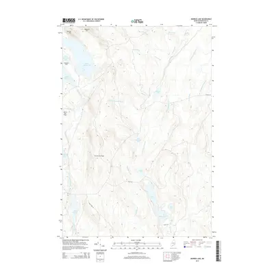
2014 Map of Monroe Lake
USGS Topo · Published 2014About this map
Monroe Lake and Little Musquash Lake sit at the center of this remote section of Washington County, where a complex network of glacial lakes and interconnecting streams defines the landscape. The hydrography is dominated by the Machias River, which links First Machias Lake, Second Machias Lake, and the expansive Third Machias Lake. High ground is found at Wabassus Mtn and Getchel Mtn in the north, providing a stark contrast to the lower-lying Midland Flats. The presence of timber and utility access is indicated by Stud Mill Rd and Sugar Camp Rd, highlighting the managed forest character of this Maine interior. This 2014 survey documents the modern drainage patterns and naming conventions for the numerous brooks and ridges, such as Cherry Tree Ridge and Second Lake Ridge, that shape this northern watershed.
Find a feature on this map
31 named features on this map. Tap any name to fly to it.
Don’t see what you’re looking for? This feature index may not catch every label — zoom into the map to look around manually.
Map Details
Editions of this 2014 Monroe Lake Map
This is the sole edition of this map. No revisions or reprints were ever made.
Other maps of this area

1941 · Wesley
USGS Topo · 1:62,500

1941 · Tug Mountain
USGS Topo · 1:62,500

1941 · Big Lake
USGS Topo · 1:62,500

1941 · Wabassus Lake
USGS Topo · 1:62,500

1943 · Big Lake
USGS Topo · 1:62,500

1943 · Tug Mountain
USGS Topo · 1:62,500

1943 · Wesley
USGS Topo · 1:62,500

1943 · Wabassus Lake
USGS Topo · 1:62,500

1952 · Big Lake
USGS Topo · 1:50,000

1953 · Wabassus Lake
USGS Topo · 1:62,500