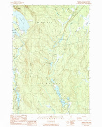
1990 Map of Monroe Lake
USGS Topo · Published 1990About this map
Machias River drainage systems define this interior landscape of Washington County, where a complex network of glacial lakes and streams reflects the hydrologic character of the Maine woods. The northern reaches are dominated by the Third Machias Lake, punctuated by Norway Island and the broad Midland Flats. Moving south, the terrain transitions through several distinct townships, including T 43 M D B P P and T 37 M D B P P, where the waterway connects Second Machias Lake and First Machias Lake. This area was documented in the late 20th century, showing a territory largely shaped by timber management and natural watercourses. Significant topographic landmarks like Getchel Mountain and the Second Lake Ridge provide overlooks for the low-lying Hay Meadows and the interconnected basins of Monroe Lake, Fourth Lake, and Third Lake.
Find a feature on this map
38 named features on this map. Tap any name to fly to it.
Don’t see what you’re looking for? This feature index may not catch every label — zoom into the map to look around manually.
Map Details
Editions of this 1990 Monroe Lake Map
This is the sole edition of this map. No revisions or reprints were ever made.
Other maps of this area

1941 · Wesley
USGS Topo · 1:62,500

1941 · Tug Mountain
USGS Topo · 1:62,500

1941 · Big Lake
USGS Topo · 1:62,500

1941 · Wabassus Lake
USGS Topo · 1:62,500

1943 · Big Lake
USGS Topo · 1:62,500

1943 · Tug Mountain
USGS Topo · 1:62,500

1943 · Wesley
USGS Topo · 1:62,500

1943 · Wabassus Lake
USGS Topo · 1:62,500

1952 · Big Lake
USGS Topo · 1:50,000

1953 · Wabassus Lake
USGS Topo · 1:62,500