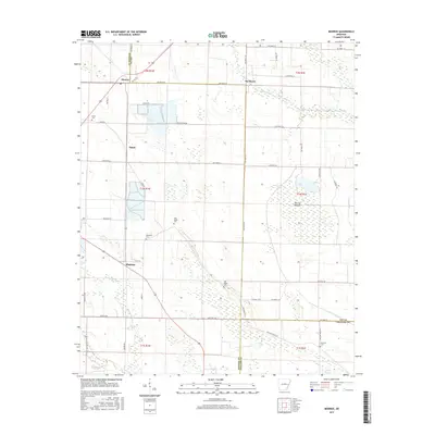
2017 Map of Monroe
USGS Topo · Published 2017About this map
Monroe and Buckhorn anchor this landscape where Lee, Monroe, and Phillips Counties meet in eastern Arkansas. The terrain is defined by a complex network of waterways and drainage, including Piney Creek and the low-lying Warrior Bottom. Family history and local heritage are preserved in scattered sites such as Bonds Cem near the western edge and Pine Ridge Cem further south. The map reveals a land heavily shaped by agricultural management, evidenced by numerous named roads like Hog Farm Ln and Minnow Farm Rd, as well as engineered water features like Lateral Number 2. Small clusters of settlement at Smale and Whitehall show the persistence of rural communities within this alluvial plain. The boundary lines for T2N R1W and surrounding townships provide the legal framework for the sectioned fields that stretch across Cypress Swamp and the banks of Crooked Cr.
Find a feature on this map
52 named features on this map. Tap any name to fly to it.
Don’t see what you’re looking for? This feature index may not catch every label — zoom into the map to look around manually.
Map Details
Editions of this 2017 Monroe Map
This is the sole edition of this map. No revisions or reprints were ever made.
Other maps of this area

1940 · Marvell
USGS Topo · 1:62,500

1940 · Holly Grove
USGS Topo · 1:62,500

1940 · Brinkley
USGS Topo · 1:62,500

1940 · Marianna
USGS Topo · 1:62,500

1948 · Helena
USGS Topo · 1:250,000

1950 · Helena
USGS Topo · 1:250,000

1955 · Helena
USGS Topo · 1:250,000

1956 · Marvell
USGS Topo · 1:62,500
1957 · Marianna
USGS Topo · 1:62,500

1957 · Holly Grove
USGS Topo · 1:62,500