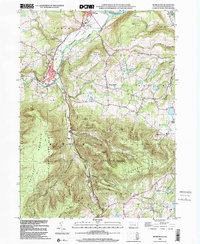
1999 Map of Monroeton
USGS Topo · Published 2001About this map
Susquehanna R flows across the northern edge of this landscape, where the town of South Towanda meets the broad Towanda Flats. The map reveals a transition from these riverbottom lands into the steep, heavily wooded terrain of the Tioga State Forest and State Game Lands No 36 to the south. Historically significant transport routes are evident through the valley, notably the Old Railroad Grade and a Pipeline that parallel Towanda Creek and its South Branch. Local history and genealogy are anchored by small settlements like Monroe and Kellogg, alongside family burial grounds such as Cole Cem and Kellogg Cem. The presence of an Airfield near the river and a Gaging Sta on the creek highlights the area's mix of rural infrastructure and natural resource management.
Find a feature on this map
40 named features on this map. Tap any name to fly to it.
Don’t see what you’re looking for? This feature index may not catch every label — zoom into the map to look around manually.
Map Details
Editions of this 1999 Monroeton Map
This is the sole edition of this map. No revisions or reprints were ever made.
Other maps of this area

1923 · Towanda
USGS Topo · 1:62,500

1926 · Towanda
USGS Topo · 1:62,500

1939 · Sayre
USGS Topo · 1:62,500

1942 · Sayre
USGS Topo · 1:62,500

1943 · Towanda
USGS Topo · 1:62,500

1943 · Monroeton
USGS Topo · 1:62,500

1943 · Powell
USGS Topo · 1:62,500

1945 · Powell
USGS Topo · 1:62,500

1948 · Sayre
USGS Topo · 1:62,500

1954 · Williamsport
USGS Topo · 1:250,000
Featured Places
- Wysox Township, PA
- Asylum Township, PA
- Albany Township, PA
- Kellogg, Monroe Township
- Uhdey, Asylum Township