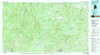
1986 Map of Monroeville
USGS Topo · Published 1989About this map
The Alabama River and Tombigbee River define this mid-1980s landscape, winding through a heavily forested region of southwest Alabama where timber and river access shaped the settlement pattern. Large tracts such as the Scotch State Wildlife Management Area and the Upper State Wildlife Sanctuary occupy much of the terrain between the river forks, while the impoundment of Claiborne Lake reflects later 20th-century water management.
Find a feature on this map
286 named features on this map. Tap any name to fly to it.
Don’t see what you’re looking for? This feature index may not catch every label — zoom into the map to look around manually.
Map Details
Editions of this 1986 Monroeville Map
2 editions found
Other maps of this area

1943 · Choctaw Bluff
USGS Topo · 1:62,500

1943 · McIntosh
USGS Topo · 1:62,500

1944 · McIntosh
USGS Topo · 1:62,500

1946 · Choctaw Bluff
USGS Topo · 1:62,500

1953 · Montgomery
USGS Topo · 1:250,000

1953 · Andalusia
USGS Topo · 1:250,000

1953 · Hattiesburg
USGS Topo · 1:250,000

1953 · Meridian
USGS Topo · 1:250,000

1956 · Montgomery
USGS Topo · 1:250,000

1957 · Meridian
USGS Topo · 1:250,000